Cool and damp to start the week; Multiple 90 degree days are in sight
We have a pair of mostly cloudy days with on and off light rain before temperatures feel more like summer starting on Wednesday.
Share:
More Stories
1:46

Stormy pattern this week in the Hudson Valley
17h ago1:46

Wet start to the week in the Hudson Valley; sunshine returns midweek
7ds ago1:16
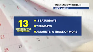
Streak of weekends with rain set to continue for lower Hudson Valley
13ds ago1:46

Sunny and clear Monday in the Hudson Valley before temps soar later this week
14ds ago1:46

Memorial Day weekend ends with beautiful evening in the Hudson Valley
20ds ago
News 12 weather blog
30ds ago1:46
Stormy pattern this week in the Hudson Valley
17h ago1:46
Wet start to the week in the Hudson Valley; sunshine returns midweek
7ds ago1:16
Streak of weekends with rain set to continue for lower Hudson Valley
13ds ago1:46
Sunny and clear Monday in the Hudson Valley before temps soar later this week
14ds ago1:46
Memorial Day weekend ends with beautiful evening in the Hudson Valley
20ds agoNews 12 weather blog
30ds agoGet ready for another up and down week of weather! The cooler and cloudy weather with off and on spotty drizzle and light rain showers will linger through tomorrow.


Wednesday, more breaks of sun return with warmer weather and just a couple of passing showers.
Thursday will be a bit more of an impactful weather day with temperatures returning to the 90s. It will be much more humid with a gusty afternoon or evening thunderstorm possible.
Friday and Saturday will not be as hot, but as we head into next week, there is a chance for our first heat wave of the season. Next week will be the first full week of summer as summer begins this Friday night at 10:42 p.m.
Have a great Monday!
FORECAST:
TODAY: Cloudy and cool with times of drizzle. Highs around 66 degrees.


TONIGHT: Cloudy and cool with spotty drizzle continuing. Lows near 60 degrees.

TUESDAY: Mostly cloudy with more off and on light showers. Highs around 72 degrees. Lows near 64 degrees.


WEDNESDAY: Clouds and sun. A few showers. Warmer. Highs around 85 degrees. Lows near 69 degrees.
THURSDAY: JUNETEENTH — Sun and clouds. Hot and humid. A few scattered, gusty thunderstorms will be possible. Highs around 92 degrees. Lows near 67 degrees.
FRIDAY: SUMMER BEGINS 10:42 p.m. — Sun and clouds. Cooler, but still warm. Highs around 83 degrees. Lows near 62 degrees.
SATURDAY: Mostly sunny. Highs around 84 degrees. Lows near 67 degrees.
SUNDAY: Sun and clouds. Spotty shower or thunderstorm. Highs around 90 degrees. Lows near 70 degrees.

More from News 12
1:46
Stormy pattern this week in the Hudson Valley
1:46
Wet start to the week in the Hudson Valley; sunshine returns midweek
1:46
Sunny and clear Monday in the Hudson Valley before temps soar later this week
1:46
Memorial Day weekend ends with beautiful evening in the Hudson Valley
News 12 weather blog
1:46
